

Investigative geolocation: A journalist's guide to verifying time & place
Use shadows, street signs, and satellite data to forensically confirm the location and timeline of an image

In a time when digital misinformation is everywhere, it’s just as important to find out where a photo, video, or event took place as it is to find out who and what it was.
Geolocation (geolocating) is a tool that investigative journalists use to turn a piece of evidence from a simple assertion into a verifiable fact linked to a specific time and place. Geoguessing (using subtle hints to figure out where something is) is often used alongside geolocation.
This expertise is important for finding out about human rights abuses, checking where protests are happening, keeping track of troop movements, and proving that false flag operations are not real. It gives a story a spatial context.
👁️ Goals for learning
By the end of this tutorial, you will be able to:
Explain what photogrammetry, reverse image search, and geoguessing are all about.
Use sun-shadow analysis (chronolocation) to make sure you know when and where a scenario happened.
Use powerful mapping tools and visual databases to confirm a location within 10 meters.
For Chain of Custody, keep a record of your geolocation findings and store them properly.
Use AI ethically to process and group visual metadata so that investigations go faster.
💡 Basic ideas
Important words
Photogrammetry
The science of making measurements from photographs is often used in OSINT to calculate object sizes or distances.
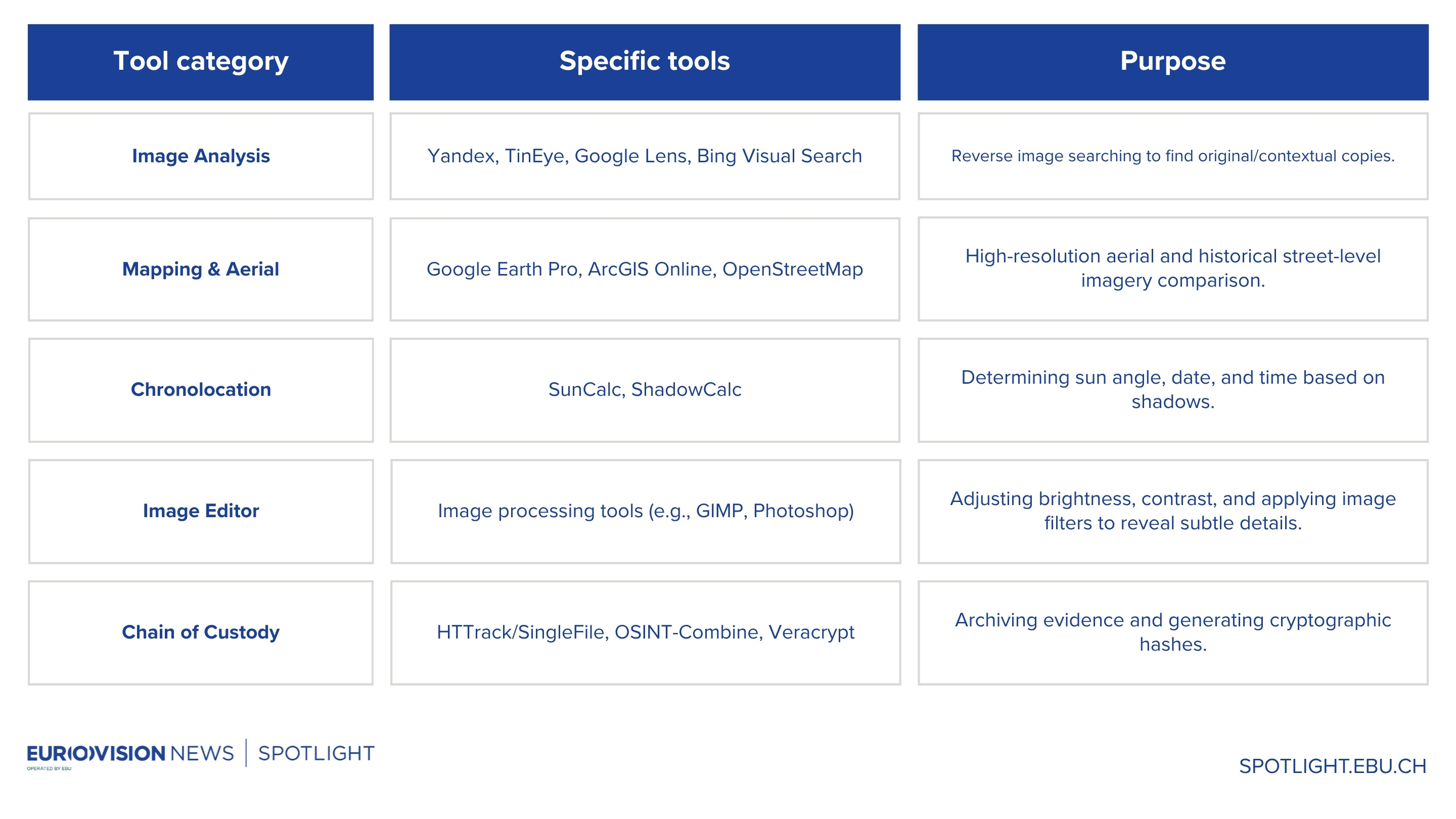
Reverse Image Search:
A query technique (e.g., using Google Lens, Yandex, TinEye) that uses an image as the input to find other instances of it online and locate the original source or context.
Geoguessing:
The practice of deducing a precise physical location from visual evidence alone (signs, architecture, terrain, etc.) without explicit coordinates.
Chronolocation:
Determining the date and time a photograph or video was taken, often achieved through analysing the direction and length of shadows.
Metadata (EXIF Data):
Embedded data in a file (like an image) that can contain the camera model, date/time stamp, and sometimes GPS coordinates (must be checked first).
⚠️ Important for Journalists: Ethical and legal limits
Privacy and consent
Just because an image or video is shared online doesn’t mean it’s okay to show the people in it, especially if they’re victims or private citizens. If you are giving away the specific address of someone’s house or business, you should always blur their face or other identifying features.
When data is made public and it leads to harassment, risk, or illegal surveillance, that crosses the ethical line. Instead of focusing on spectators' private lives, concentrate on the event and the places that are important to the public.
Legal considerations
Geolocation primarily uses publicly available data (passive OSINT), which is usually lawful. But the line is crossed if the method includes:
Unauthorised access: Trying to get into private CCTV streams or street view archives that are password-protected.
Terms of Service (ToS) violation: Mass-scraping mapping data or high-resolution images that go against a platform’s ToS.
Disclaimer: Journalists and news organisations must always consult their legal departments before publishing geolocated results, especially when they involve national security, ongoing conflicts, or people's safety.
🛠️ The Method: Putting it into action step by step
👷♀️ Practical execution (The “How”)
The central part of geolocation is iterative analysis, which means looking at minor hints to find the right place.
Scenario: Finding the place of a protest from a video on social media
First look and reverse search
Action: Use Google Lens, Yandex or TinEye to do a reverse image search on a screenshot of a critical frame.
Investigative goal: The goal of the investigation is to find the original source, date, and any previously known place or context.
Look at the big picture clues (macro clues)
Action: Make a list of the most essential, unmovable things, including distinctive bridges, large public buildings, bodies of water, mountain ranges, or certain sculptures.
Investigative goal: The goal of the investigation is to narrow the area down to a city or a small region.
Example clues: “The signs are in Cyrillic, the architecture is Soviet-era brutalism, and the land is mountainous.” Focus: Concentrate on Central Asia and Eastern Europe.
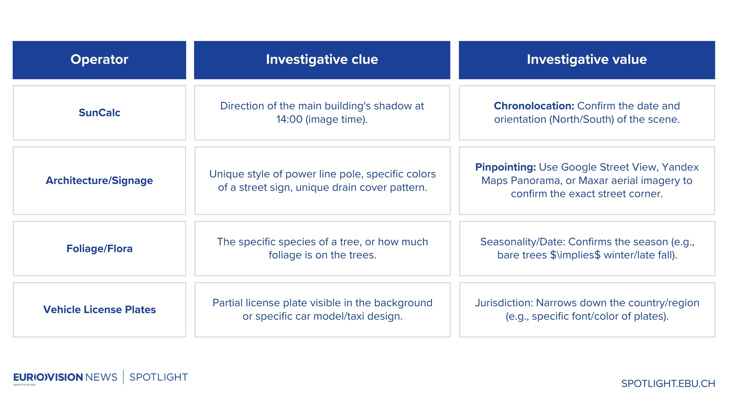
Look at the micro clues
This is the geoguessing step, where subtle details are critical.
4. Verification and measurement
Action: After identifying a potential location (such as a specific intersection on Street View), use Google Earth Pro’s measurement tools to align the heights and distances of objects in the video/photo with the satellite image (photogrammetry).
Investigative goal: Build high trust by making sure that important details, such as the distance between a lamppost and a traffic signal, are precisely the same.
💾 The Audit Trail: Keeping Data Safe
You can’t trust a geolocation until there is a clear, repeatable audit path that proves Chain of Custody.
Capture and archive: Use tools like SingleFile or a dedicated browser extension to preserve the original source page (e.g., a social networking post) as a full, unchanging HTML file. Don’t only look at screenshots of the original post.
Write down the steps (required): Make a chronological log file, like a notebook or spreadsheet, that lists
Original URL: (The video or post on social media)
When and where the picture was taken:
Tools used: (for example, Yandex for R.I.S. and SunCalc parameters)
Identified coordinates: (The last Lat/Long that was found)
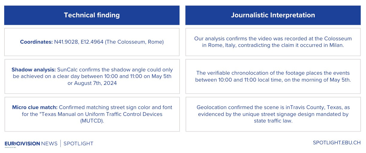
The Why: A short explanation of the main visual cues utilised to confirm (for example, “Matched unique church steeple at N48.8584, E2.2945”).
Make a Hash: Make a SHA-256 hash of the original video or image file that you downloaded and the archived HTML page. This digital signature shows that the file hasn’t changed since it was collected.
Command Line Example (Linux/macOS): shasum -a 256 [filename]Secure Storage: To prevent unauthorised access, save all log files, archival evidence, and hashes on an encrypted drive, such as Proton or VeraCrypt.
🧠 Check and analyse for reporting
Strategy for corroboration
Technical data check: To ensure the GPS coordinates are correct, verify them against at least two separate mapping sources, such as Google Earth Pro and OpenStreetMap. If you’re looking for a building, check old photos to make sure it was there at the time of the event.
External source check: Verify outside sources to ensure the broad area aligns with non-visual data, such as local news reports, government databases, or public documents that discuss occurrences in that area or involve the features found. For instance, if you observe a one-of-a-kind building, look for planning applications for that address in your area.
Connecting data to story: Geolocation findings must be transformed from technical data into journalistic facts that anyone can verify.
🤖 AI Assistance in Analysis
For advanced geospatial analysis, journalists need to use multimodal AI models (that can ingest and understand visual data) rather than text-based LLMs. An AI can’t “geolocate” a target image on its own (it needs maps and confirmation from a person), but it can quickly and efficiently analyse small visual clues, which speeds up the work of the human geolocator.
AI techniques for accelerating geolocation: R.A.F.T.
R.A.F.T. is a framework adopted by the Eurovision Social Newswire and Spotlight teams for a wide range of daily research and analysis tasks. From geolocation to web scraping to data analysis, R.A.F.T. is a portable, reusable asset that provides a solid structure upon which to build for non-editorial tasks and tailors the output to the journalist’s needs.
Role (R): Assign a persona (e.g., “Forensic Accountant,” “Legal Verification Expert”) - Ensures the AI uses the appropriate industry terminology and level of scepticism. Action (A): Define the specific, measurable task - Prevents generic text. Focuses AI on the immediate, time-critical task.Format (F): Demand a specific, usable output structure (e.g., Markdown table, JSON, bullet points) - Makes data instantly ready for a spreadsheet, map, or article bullet list.Tone (T): Set the language, perspective, or scepticism (e.g., “Neutral and objective,” “Sceptical”) - Prevents the AI from injecting hyperbolic or opinionated language.Feature identification and labelling: You can upload the picture and ask the AI to “Identify the utility pole structure style and compare it to documented regional standards,” or “Transcribe all non-English text visible on signs and posters.” Both of these give you instant keywords for map searches.
Pre-analysis of temporal clues: The AI is asked to determine the azimuth (direction) of the main shadow and the altitude (height) of the sun from the length of the shadow. This gives SunCalc an initial hypothesis to work with.
For more on using AI prompting for geolocation:

⚠️ IMPORTANT WARNING: The risk of hallucination and privacy
Never send sensitive, source-provided, or private data (like private login information or parts of confidential documents) to public LLMs. This could expose the source and violate privacy.
Use only private, dedicated enterprise AI solutions or models on closed systems for sensitive information.
Because of the high risk of hallucination, people need to check all AI-processed data against the original source documents and pictures. A human journalist must verify every fact reported by the AI using a source other than the AI itself.
🚀 Next Steps and Practice
Exercise to Practise
The “tourist clue” challenge
Get a vacation picture from a friend or family member that shows only a certain building facade and a small part of a road sign in a different country.
Use the visual clues (building, language, sign colour/shape, and shadow angle/time) to find the exact intersection without asking them.
Check your accuracy by comparing your final latitude and longitude with theirs.
🌎 Advanced Resources Geolocating Methods:
SunCalc is an interactive map that shows the sun's position and the shadow (chronolocation) at any time and place.
PimEyes and FaceCheck are advanced reverse image search engines that can help you find the original social media post if you can see the face. Be very careful when using this.
Sentinel Hub is an open-source platform that lets you view high-resolution satellite imagery (which is helpful for hard-to-reach areas).
✅ Important things to remember and investigative principles
Put the micro clues first: A power line, a distinctive streetlamp, or a painted curb are just a few of the small, one-of-a-kind things that set a city apart from an intersection.
Always double-check: At least two independent mapping sources, and your own derived Chronolocation, must confirm your final Lat/Long.
Document everything: A chain of custody (logs, hashes, archival sources) is not up for discussion. Without it, what you found is just an accusation, not a fact that can be proven.
Ethical constraint: Don’t tell anyone where private individuals or victims are, just because you can find them on a map. Privacy considerations must come after the public’s interest.
AI is a tool, not a final check: LLMs can translate and process, but they can’t check facts. The journalist is responsible for the final check of all technical data.
👁️ Coming next week…
🧭 Mastering Video Verification and Chronolocation
We will go from still pictures to moving video and learn how to check its authenticity and timestamp. This tutorial will show you how to use Google Historical Imagery (Earth Pro, Maps, Timelapse) to compare landmarks, changes in construction, and cycles of vegetation. In the end, it will show you when a video was recorded and turn simple footage into reliable, chronological proof.
🎓 Other tutorials in the Deep Web, geolocation, and metadata mastery series


 | A guest post by
|