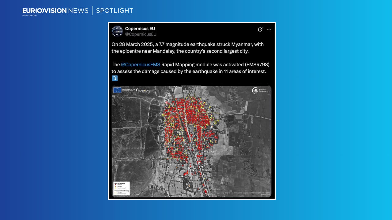
Copernicus map of damage in Myanmar village after earthquake raises questions
Earlier satellite images show widespread damage was already present at this location before the earthquake.
CLAIM
A satellite image published by Copernicus, which carries out earth observation as part of the European Union’s space programme, is described as showing a village razed to the ground by the devastating earthquake that struck on March 28.
BACKGROUND
Images of widespread devastation in Myanmar have flooded social media after the 7.7 magnitude earthquake that struck near the country’s second-largest city, Mandalay, on March 28. Latest figures by the junta government put the death toll at over 2,700 people with more than 4,500 injured.
On Monday, March 31, the X account of Copernicus, the European Union space programme’s Earth observation initiative, published a map of a village located just northwest of Mandalay covered in red dots, denoting totally destroyed buildings, and attributing the destruction to the earthquake.
Copernicus followed up with a post saying: “The image is a data visualisation based on @CopernicusEMS data, which depicts extensive damage in the village of Pha Duu (Pa Du). It shows that more than 1,200 buildings and 8 km of roads were possibly damaged or destroyed.”
The image originated from the Copernicus Emergency Management Service (EMS), which describes itself as providing “mapping products based on satellite imagery” as well as early warning products for forest fires, floods and drought.
The Rapid Mapping module mentioned in the post above “supports the emergency response phase with timely data for immediate disaster management activities,” according to its website.
In other words, Copernicus EMS was used to detect damage through almost real-time data received from satellites.
However, questions were raised by OSINT accounts on X about the attribution of the damage found in these images.
METHOD
The Copernicus satellite image mapping damage in the village of Pa Du, northwest of Mandalay, appeared like this on the database with a legend showing all the red dots denoted destroyed buildings.
However, a satellite image on Google Earth of the exact same location showed many of the buildings already heavily damaged earlier. Data attribution details published by Google said these satellite images were collected on June 10, 2024.
Only a small number of the buildings marked as entirely destroyed by Copernicus EMS were visibly standing and appeared undamaged in the older Google Earth image seen below.
Below is another section comparing the recent satellite imagery of the village by Copernicus and older images on Google Earth also showing many of the buildings had already been destroyed.

Much of the damage may, in fact, date back to 2023. NASA’s Fire Information for Resource Management System has previously recorded major fires in Pa Du village. One on May 22, 2023 and another on June 26, 2023.
Questions about the damage attribution have been flagged to Copernicus by OSINT accounts on X. No comment has been forthcoming so far.
RATING
The image published by Copernicus is explicitly described as showing damage in the aftermath of the earthquake but earlier satellite images show widespread damage was already present at this location before the earthquake. Therefore, the image has been rated as missing context.
SOURCES
Copernicus.eu. (2024). About | Copernicus EMS On Demand Mapping. [online] Available at: https://mapping.emergency.copernicus.eu/about/ [Accessed 1 Apr. 2025].
Google Earth. [online] Available at: https://earth.google.com/web/search/Pa+Du,+Myanmar/@22.10079567,95.92651788,91.85914722a,1421.42468829d,35y,360h,0t,0r/data=CiwiJgokCfyCy4CbLzZAEfqCy4CbLzbAGTEXlAns-ElAIXKaWf-cSUrAQgIIAToDCgEwQgIIAEoNCP___________wEQAA [Accessed 1 Apr. 2025].
X (2025) On 28 March 2025, a 7.7 magnitude earthquake struck Myanmar, with the epicentre near Mandalay… Available at: @CopernicusEU [Accessed 1 Apr. 2025]
X (2025) The image is a data visualisation based on @CopernicusEMS data… Available at: @CopernicusEU [Accessed 1 Apr. 2025]
X (2025) this is non sense this damage is not earthquake related pa du village was burned… Available at: @il_kanguru [Accessed 1 Apr. 2025]


